
The Southern Ocean is a remote region of the world that holds significant influence over the Earth’s climate. Compared with other areas on Earth, its atmosphere is relatively untouched by atmospheric particles that come from human activities. This makes the Southern Ocean a unique place to study what the atmosphere might have been like in preindustrial times.
Climate projections for the entire Earth are sensitive to interactions of aerosols, clouds and precipitation in the atmosphere over the Southern Ocean. Seasonal variations in Southern Ocean aerosol properties are well documented, but to improve the accuracy of climate models, scientists need more information about the properties of low clouds and precipitation in the region.
An upcoming field campaign supported by the U.S. Department of Energy (DOE) will fill in knowledge gaps about the seasonal cycle of clouds and precipitation over the Southern Ocean. As a result, these data are expected to have big impacts on regional and global climate modeling.
The Cloud And Precipitation Experiment at Kennaook (CAPE-K) is scheduled to run from April 2024 to September 2025 in northwestern Tasmania.
Gerald “Jay” Mace, a professor of atmospheric sciences at the University of Utah, is the lead scientist of CAPE-K. His co-lead is Roger Marchand, a research professor at the University of Washington.
The campaign’s science team consists of scientists from universities and research institutions in the United States and Australia.
CAPE-K received support from a recent DOE proposal call for field campaigns that would improve the understanding and modeling of clouds and aerosols, as well as their interactions and coupling with the Earth’s surface.
DOE’s Atmospheric Radiation Measurement (ARM) user facility will provide instruments and infrastructure for CAPE-K. For 30 years, ARM has collected atmospheric data in under-observed regions around the world, including the Southern Ocean. ARM data are freely available for scientists worldwide to download and use.
A powerful collaboration
CAPE-K will take place in a region unlike many others on the planet.
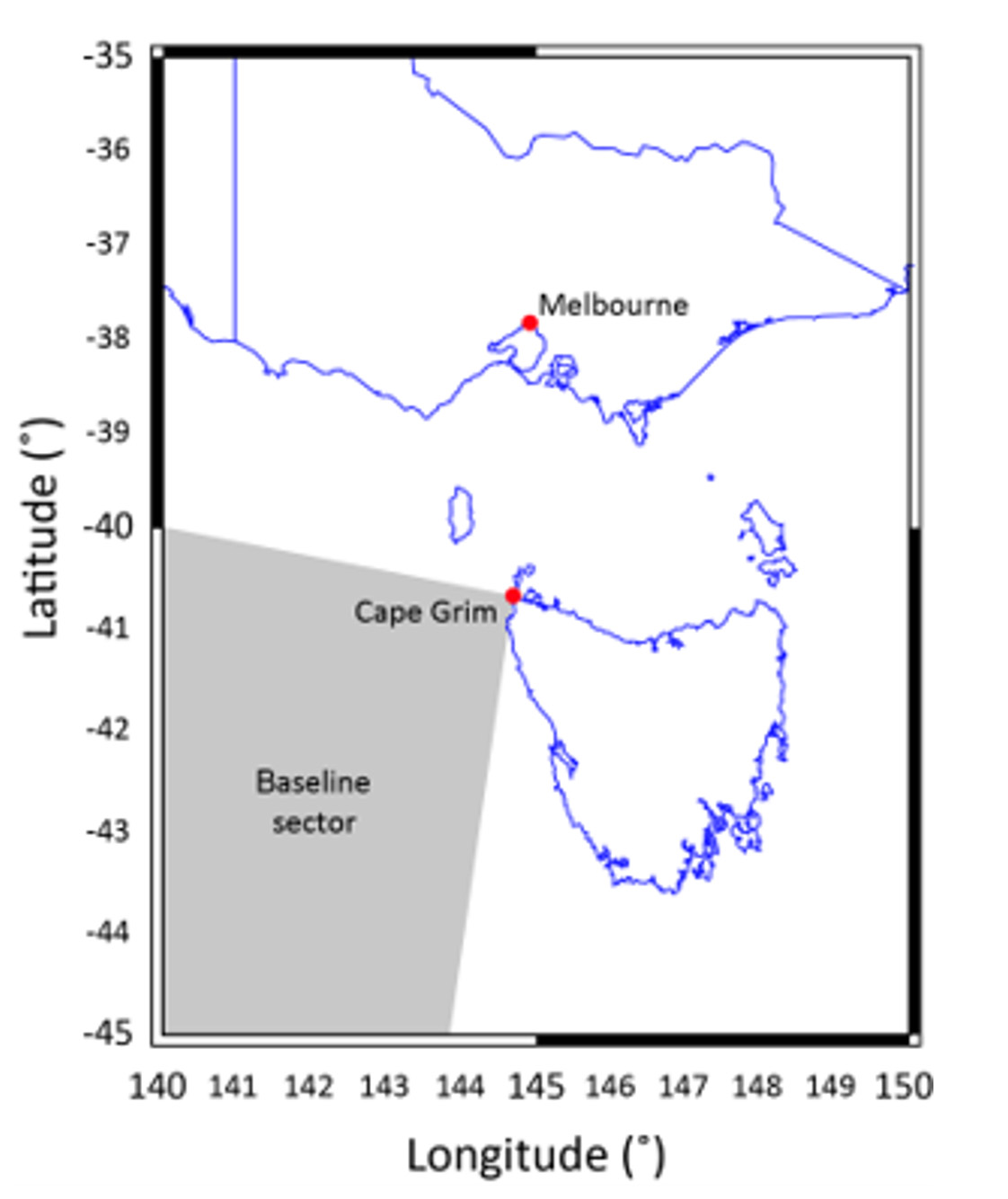
ARM instruments for CAPE-K will be located on the northwestern tip of Tasmania. The baseline sector represents clean air that has not passed over land.
Download Full-Res Image“It’s the only place where there’s a circumpolar ocean current on Earth,” says Mace, who has current funding for Southern Ocean research through DOE’s Atmospheric System Research (ASR). “And so, you have this shoaling of deep water that absorbs carbon and heat. And then that, coupled with other things like recovering ozone, is causing the Southern Hemisphere to be in a state of change.”
The campaign will enable three science objectives:
- Document the seasonal cycle of Southern Ocean low-cloud and precipitation properties and examine how they co-vary with aerosol and with dynamical and thermodynamical factors.
- Compare and contrast these relationships with observations from other surface sites and campaigns, including other ARM sites.
- Study aerosol-cloud-precipitation interactions in pristine marine low clouds and explore how these interactions can best be represented in models at various scales.
ARM plans to conduct CAPE-K at the Kennaook/Cape Grim Baseline Air Pollution Station. This station is managed by the Australian Bureau of Meteorology (BOM) and the Commonwealth Scientific and Industrial Research Organisation (CSIRO).
Established in 1976, the station often measures clean air masses that have not passed over land. This is an important vantage point to have as scientists try to determine how much influence human activities have on the Earth’s energy balance.

PHOTO CREDIT: Australian Bureau of Meteorology.
The Kennaook/Cape Grim Baseline Air Pollution Station in Tasmania is expected to be the main site for ARM’s Cloud And Precipitation Experiment at Kennaook (CAPE-K). The CAPE-K campaign is scheduled from April 2024 to September 2025.
Download Full-Res Image“The CAPE-K campaign will provide important information on aerosol-cloud-precipitation interactions to help reduce a large source of uncertainty in current climate models,” says DOE ARM Program Manager Sally McFarlane. “The Kennaook/Cape Grim Baseline Air Pollution Station is an ideal location for this study due to its extensive long-term record of aerosol and gas-phase chemistry measurements and its unique location, which results in frequent sampling of pristine air masses from the Southern Ocean.”
For CAPE-K, ARM will provide a portable observatory called an ARM Mobile Facility, which consists of instruments, shelters, and data and communications systems. ARM instruments operate 24 hours a day, seven days a week, with onsite technicians monitoring the facility around the clock.
In addition to collecting continuous data on cloud and precipitation properties, ARM plans to provide aerosol measurements that will complement those from the baseline station.
Mace is the first person to serve as a lead scientist for multiple ARM Mobile Facility deployments. In 2010 and 2011, Mace led an ARM campaign in Colorado that measured the properties of wintertime clouds and precipitation around the ski town of Steamboat Springs.
Return trips to the Southern Ocean
CAPE-K will mark ARM’s first trip back to the Southern Ocean since 2018, when it finished conducting simultaneous campaigns in the region.
Over a five-month span, ARM instruments collected data on a supply vessel that traveled back and forth between a port in southeastern Tasmania and a set of research stations in the Antarctic.
The other campaign was a two-year deployment to Macquarie Island, which is about halfway between New Zealand and Antarctica, to study surface radiative fluxes and cloud and aerosol properties.
Several researchers from CAPE-K’s science team worked on those two ARM campaigns.
Marchand led the Macquarie Island campaign and was a co-investigator for the other Southern Ocean campaign. CAPE-K co-investigator Alain Protat, from BOM, was also co-investigator for both of ARM’s past Southern Ocean campaigns.
Protat is a CAPE-K co-investigator along with CSIRO’s Ruhi Humphries and Melita Keywood.
CAPE-K also has a modeling and analysis team, which includes former BOM head of research Peter May. He helped set up an ARM site that operated in Darwin, Australia, from 2002 to 2014.
Once CAPE-K is underway, the campaign will benefit even more from established partnerships with BOM and CSIRO.
The CSIRO-operated R/V Investigator will be stationed off Kennaook in July and August 2025—wintertime in the Southern Hemisphere. The ship will then travel into the air masses that flow from the prevailing southwesterly winds to collect data on aerosol, cloud, and precipitation properties.
Mace has been a passenger on the Investigator for past data-collecting missions. He looks forward to boarding the vessel again and seeing what scientific discoveries emerge from CAPE-K.
“We’re going to expect to see very clean air masses, very low aerosol air masses—perhaps some of the cleanest on Earth,” he says.