
Utahns are very familiar with snow and ice in Big Cottonwood Canyon—particularly at the Brighton and Solitude ski resorts, at the top of the canyon. But when Brendon Quirk goes up there, he’s imagining something different.
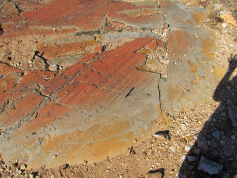
PHOTO CREDIT: Brendon Quirk
Shale of the Big Cottonwood Formation near Lake Blanche. Clear glacial striations visible, with pen aligned to striations.
“It’s a pretty interesting feeling to stand on a surface where you know there was a glacier 132,000 years ago,” he says. “You’re imagining the glacier enveloping you and filling the canyon.”
Quirk is a doctoral student in the department of geology and geophysics, and he has spent a lot of time looking for evidence of the extent of those long-gone glaciers. In a paper recently published in GSA Bulletin, Quirk and his colleagues examine the evidence that the glaciers left behind to learn more about Utah’s ancient climate. Anyone visiting Big Cottonwood Canyon can see that same evidence—if you know where to look.
Let’s start with a little glacial vocabulary. Glaciers are often described as rivers of ice. They’re what happens when ice high in mountains starts moving downhill under its own weight. Along the way, the rock under the glacier is ground down and plucked away, while rocks that fall onto the top surface are carried away to wherever the glacier deigns to take them.

PHOTO CREDIT: Brendon Quirk
A boulder from the Mill B left lateral moraine. You can see this exact boulder on the left-hand side of Broads Fork trail.
So what we have left once the glaciers melt are three key remnants: striations, erratics and moraines. Striations are grooves carved by the advancing glacier in rocks. They’re useful indicators of the direction the glacier was traveling. Erratics are those lonely boulders that tumble onto the glacier’s surface and come to rest wherever they’re at when the glacier melts, often far from their parent rock. They get their name from the fact that they’re of a rock type that doesn’t match the geology around them. Finally, moraines are the piles of rock and dirt that pile up at the glacier’s toe and margins as it plows down its path. Moraines are some of the best evidence of a glacier’s last known extent because once the glacier starts to retreat, it leaves the moraine behind.

PHOTO CREDIT: Brendon Quirk
Large boulder from the Solitude moraines sampled for cosmogenic exposure dating.
Geologists have been looking for these features for centuries, but Quirk has been using new techniques to get even more information about Utah’s ancient glaciers. One technique is LiDAR, a laser-based radar technology that helps scientists see through the vegetation and create detailed maps of terrain.
“We can, from our office, very quickly map areas of interest that might have small moraines in them,” Quirk says. “So we’re finding these small moraines that had previously gone unnoticed. If you don’t know where to look you could spend a lot of time covering a lot of ground looking for these features.”
The second technology is cosmogenic dating. Earth’s surface is constantly bombarded with invisible cosmic rays. In rocks, these cosmic rays interact with the minerals and change the chemistry slightly, enough that researchers like Quirk can detect the change. If you know the rate at which these chemical changes happen, you can tell how long a rock, like a boulder on a moraine, has been sitting at the surface.

Looking down to Lake Blanche where glaciers retreated rapidly from 14,800 years ago.
So what has Quirk learned? He’s trying to answer questions about what kind of climate produced these glaciers. Was the climate colder and drier than today, or warmer but wetter?
“We’re seeing more of a complicated story where we have a transition from cold and dry to warmer and wetter,” he says. The transition began around 19,000 years ago, just after the maximum extent of ice in the region. He’s now using what he’s learned in Big Cottonwood and comparing with glacial evidence in nearby Little Cottonwood, Bell’s and other Wasatch canyons.
“If global climate is the thing that is primarily controlling glaciation,” he says, “then we might expect the range to be synchronous as far as where ice was and when it retreated. In order to do this, we’re building a much bigger Wasatch story.”

PHOTO CREDIT: Brendon Quirk
Lake Blanche in the fall.
Here’s Quirk’s tips for glacial sightseeing in Big Cottonwood Canyon, with coordinates if you want to go find the locations yourself (you can also see them on this map):
- 40. 60628 N, 111.69677 W “The one that people are most familiar with is up at Lake Blanche,” he says. “The softer shales and siltstones have deep prominent glacial striations cut into them at the base at the rim of Lake Blanche.” Quirk collected rock samples around Lake Blanche to date the disappearance of glaciers there around 15,000 years ago.
- 40.62446 N, 111.74535 W “You can see similar glacial polish up near the Storm Mountain picnic area,” he says, just above the stairs power plant. “If you follow the trail that climbers use to come down near the water pipe you go to the top of a bedrock knob and you can see polished smooth Big Cottonwood quartzite with striations. You can put your hand on a surface where a glacier was from the penultimate glaciation.”
- 40.61586, 111.58981 W “As you’re driving up near the Redman Campground by Solitude, if you go walking you can see ridges throughout that campground,” Quirk says. “Those are actually moraines that we dated up there so we know that ice abandoned that position at that campground 15,000 years ago.”
- 40.63207 N, 111.72597 W Hikers on the Broads Fork trail will also encounter moraines, walking along the level ridge of a moraine just above the trail’s initial switchback ascent. “We sampled boulders just off the trail there,” Quirk says. “You’re walking along a lateral moraine from a glacier that abandoned that position 20,000 years ago.”
- 40. 63377 N, 111.72363 W Striated quartzite bedrock just above the Lake Blanche trailhead parking lot has an age of 18,000 years. “This shows that while the glacier there abandoned the higher elevation moraine 20,000 years ago it didn’t retreat from the lower elevation bedrock until 18,000 years ago,” Quirk says. “So, in fact, we know the glacier was thinning from 20,000 to 18,000 years ago and only then retreating uphill.”