
Only if you’d walked on volcanic rock less than a month old, still steaming, would you know that the leftover heat keeps the rocks warm with heat escaping through the numerous cracks, even in a Hawaiian downpour. Only if you’d lived through an earthquake a day, unleashed by the collapse of the now partially empty magma chamber of the Kilauea volcano, would you know just what magnitude of quake it takes to almost knock you off your feet.
Fan-Chi Lin, Jamie Farrell and Matthew Miller know. They’ve recently returned from Hawaii, where they placed an array of seismometers around the volcano. These scientists acted quickly, aided by a special rapid-response grant from the National Science Foundation (NSF), to take advantage of an extraordinary opportunity to understand a volcano like never before.
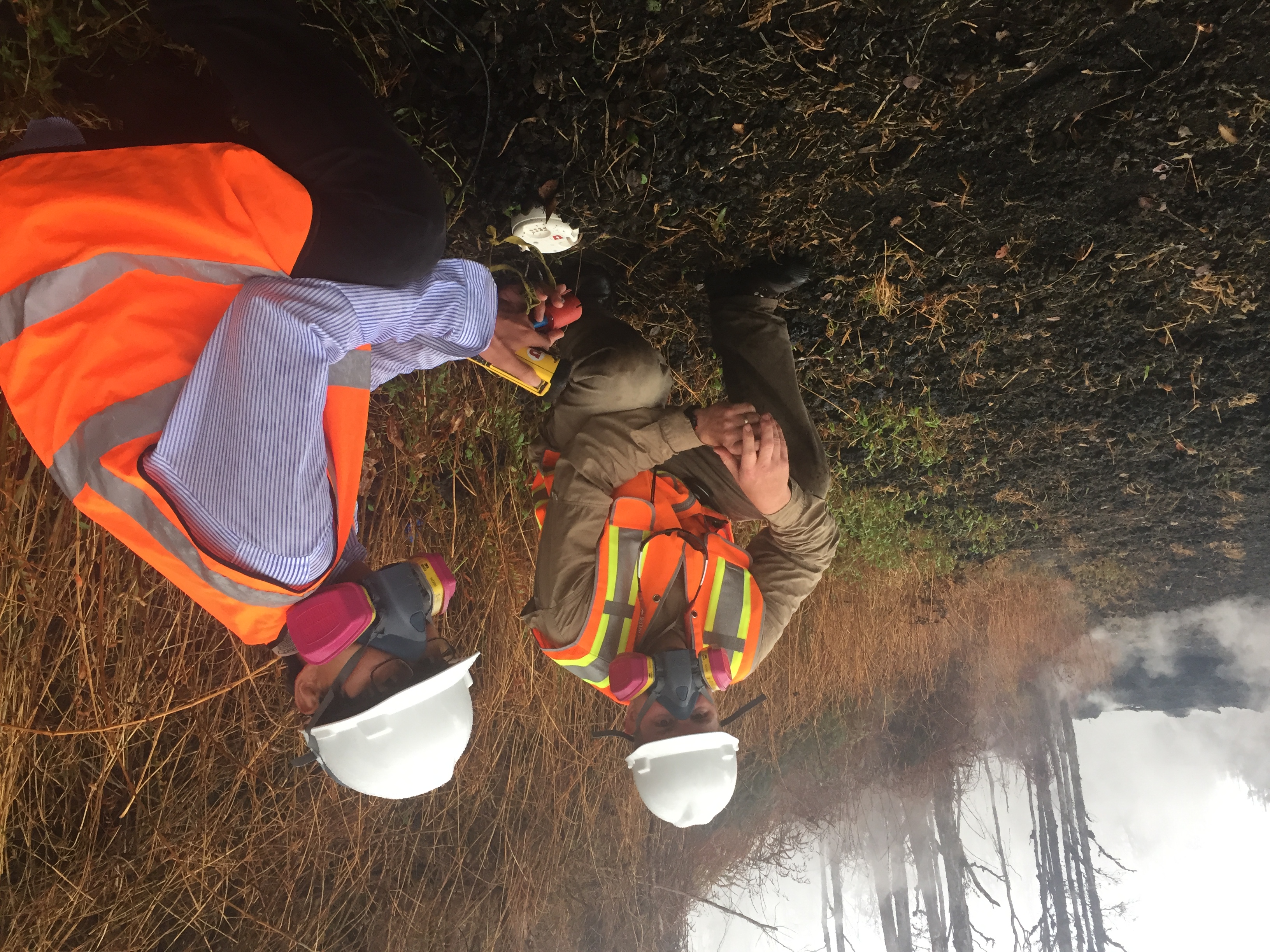
PHOTO CREDIT: Brian Shiro (USGS)
Farrell (left) and Lin (right) place a seismometer (white disk, partially buried).
“The scientific target is trying to see whether we can detect how the magma moves from the summit all the way to the lower rift zone,” Lin says. “There’s a big uncertainty there. One component of our study is whether we can finally reveal what the subsurface magma channel looks like.”
Typically, you’re much more likely to find Lin and Farrell, of the U’s geology and geophysics department and seismograph stations, studying a different volcano: the caldera beneath Yellowstone National Park. Seismologists can see into the subsurface of the earth by watching how seismic waves move through the earth. Seismometers had previously been expensive to build, bulky and often time-consuming to deploy, limiting what seismologists could see.
But now, with technology recently made available to scientists, U. seismologists can rapidly deploy small, portable mini-seismometers, smaller than a football, wherever they want. Need to get an overview of seismicity around Yellowstone’s Upper Geyser Basin? Spread out a wide array. Need to focus in on the arteries that feed Old Faithful? Pack the sensors in closer. Need to get a high-resolution picture over a large area? Put the sensors out in a tight grid, wait for a day or two, and then move the entire grid.
The portable seismometers, managed by the University of Utah Seismograph Stations, have allowed them to do all that, and to understand Yellowstone’s most famous feature as never before.
Now to Kilauea.
On May 3, 2018, the first of two dozen fissures in Kilauea’s East rift zone opened, spewing lava and hot toxic gases. The fissures are cracks in the ground that drain the volcano’s magma chamber. It’s not the classic volcanic eruption of lava blasting only from the summit. Instead, the lava lake at the summit has drained and the summit is sinking as the magma chamber empties. Today, around 600 homes have been destroyed and the lava, hardened into the black igneous basalt rock, covers nearly 10 square miles.
As the reports of Kilauea’s eruption began, both Farrell and Lin, independently of each other, thought of what their portable seismometers could learn from such an eruption. Just like in Yellowstone, seismic observation of Kilauea had previously been limited to sparsely distributed seismometers. So many questions, such as the structure of the channels that move lava to the East rift zone, had been unanswered.

PHOTO CREDIT: Fan-Chi Lin
Seismometer (white) in the foreground.
“You need high resolution, very dense station coverage to be able to see tiny, small seismic signals that relate to magma propagation,” Lin says. “Right now we know for sure there’s magma flow down there.”
The two seismologists, in parallel, reached out to the Hawaiian Volcano Observatory (HVO) to explore the possibility of coming out to collect data. They soon joined efforts and applied for funding under the NSF’s RAPID program. Typically, NSF reviews of research proposals can take months. But, recognizing that sometimes nature moves faster than that, NSF established RAPID to help scientists take advantage of time-sensitive research opportunities.
With funding from NSF and support from the U.S. Geological Survey, Lin and Farrell left for Hawaii, along with undergraduate Miller. Lin arrived first, after attending a pre-scheduled conference at Honolulu. “The first day I arrived, I would look out to the sky and it was all bright red,” he says, referring to the incandescent red lava. “It’s surreal – it looked like a sunset, but it was not a sunset.”
Farrell was also struck by the starkly changed landscape. “You’re driving down the road and turn a corner and all of a sudden, there’s a lava flow,” he says. “You can go from pretty normal-looking to almost Armageddon pretty fast.” Cracks in the ground vented heat and toxic sulfur dioxide. “You can hear the lava fountain that’s producing the river,” Farrell says.” It’s like a roar.” The lava river itself moved surprisingly fast, he says. “You may be able to outrun it for a short distance – but not for very long.”
Over four days, the team placed 82 seismometers. Under the supervision of HVO scientists and in conjunction with Hawaii Civil Defense, they donned gas masks and hard hats to work safely around the lava flows. The sensors will continuously monitor ground shaking at locations from the summit of Kilauea down to the East rift zone. “We have to keep an eye on them because there’s a couple that are pretty close to the lava flow,” Farrell says. “HVO has crews on the ground that can pull them out if they’re in danger.”
And there’s plenty of seismic activity for them to record. While Farrell and Miller were placing sensors at the summit, a magnitude 5.3 earthquake shook the ground from practically directly beneath them. The sensors that now ring the summit will be able to locate where those earthquakes originate and help volcanologists understand what happens to a volcanic crater as the magma chamber empties.
The researchers will return to Hawaii in mid-July to retrieve the sensors and then will share the data with the scientific community. And, depending on the volcano’s activity, they may set the sensors out for a second deployment.
“We got our sensors up pretty darn close,” Farrell says, “They’re in danger of being covered by lava if it breaks out or changes paths or if a new fissure opens up. But you get really good data if you can get that close. That’s a risk we were willing to take.”